My Travel and History Blog, Focussing mostly on Roman and Mediaeval Times
18 Aug 2012
Once Upon a Time - The Geology of the Curonian Spit
Once upon a time there were a fisherman and his wife who got a child late in life. Neringa they named their daughter, and she grew up big and strong. Indeed, so big and strong she was that the other children did not want to play with her, because she sometimes hurt them, She never wanted to hurt anyone, but she could not control her strength, and so she became a lonely child and sat at the shore for long times, watching the sea. She grew to a young maid, but still most villagers were wary of her because of her size and strength, and did not see her kindness and gentle heart.
So Neringa was a stranger in the village more than a member, and she watched people and often beheld the women cry when their husbands and sons did not return from their fishing tours. Then she saw the storms and high waves that capsized the boats and killed the men, and she decided to use her strength to help the villagers.
All night Neringa worked and carried sand in her apron, piling it up a few miles in front of the beach so that the storms and high waves would no longer threaten the boats of the fishermen. In the morning she had separated a safe and calm lagoon from the sea by a vast wall of sand. And the people in the village finally saw her kindness and were no longer afraid of her.

Neringa's nightly work
Another version includes the dragon Naglis who wanted to marry Neringa. When she refused him, he sent severe storms to destroy the villages, so she built the great dune to protect the villages from the dragon's wrath.

View of the Parnidis Dune from the lagoon side (in Nida)
The sandy peninsula Neringa created in one night is pretty impressive: 98 km in length and between 380 metres and 3.8 km wide, with the highest dunes up to 73 metres, separating a lagoon of 1,584 square kilometres.
This is the legend about the development of the Curonian Spit; the geographic facts are a bit more complicated, of course. But the name of the giantess, Neringa, still lives in the German (Kurische Nehrung) and Lithuanian (Kuršių nerija) words.
The basis of the Curonian Spit and lagoon is a 2000 metres thick crystalline sedimentary basin - the Baltic Syneclise - from the Paleozoic Era (542-251 million years ago), with additional formations from the Mesozoic Era (250-65 million years ago), and a layer of Pleistocene sediments that is 80-160 metres thick and consists mostly of the remains of glacier moraines from earlier ice ages. Its present look is a rather young development, going back to the last ice age (the Weichselian glaciation BC 115,000-11,700; also known as Würm in the Alpes, Devensian glaciation in the UK and Wisconsin glaciation in the US) and began about 16,000 years ago when the glaciers started to melt (yet again).

View from the dunes towards the harbour of Nida
The geological history of the spit is closely connected with that of the Baltic Sea. The development is somewhat complicated and parts of it are still discussed, but I'll try to walk you through. *grin*
The melting ice created a proglacial lake that 12,000 years ago covered most of the future Baltic Sea area (except for the Bothnian Bay between Sweden and Finland that was still covered by ice), framed in the north by the 2500 metres thick Scandinavian icesheet. Since the ocean level was 90 metres lower than today, there was a land connection between Sweden / Denmark / Germany, cutting the lake off. The level of the lake rose to 28 metres above sea level.
About 10,300 years ago, the melting glaciers caused the ice barrier between the proglacial lake and the sea - the land along lakes Mälaren, Vättern and Vänern in Middle Sweden - to break so that the lake drained to sea level (which at the time was still 65 metres below NNl).
The following influx of salt water led to a period called the Yoldia Sea (named for a marine bivalve - Yoldia arctica - living there), a brackish sea that lasted about 300 years.

Parnidis Dune
The peninsula in the background belongs to the Kaliningrad Oblast (Russia)
But now the glacioisostatic rebound (also refered to as glacial isostatic adjunstment) of the land came into effect. That process was caused by the lessened pressure of the ice that had pushed the earth crust into the mantle; the mantle material now started to reflow under the crust. This rebound caused the land to lift and the connection between the North Sea and the Yoldia Sea closed again 9,500 years ago, creating the Ancylus Lake (named for a fresh water snail, Ancylus fluvialis). The deep water current that brought in the salt water was cut off and the Ancylus Lake became a fresh water lake supplied by meltwater from the glaciers.
The rising water again reached a 'weak spot', the Darss Threshold, and again the different levels of the ocean and the lake led to an influx of salt water. This period 8000 years ago is called the Littorina Sea (after the marine snail Littorina littorea). The islands of Denmark and the Belt / Kattegatt connection developed. At the time the water level was higher than today.
The post-glacial rebound continued (it still does, about 1 cm per year), and the connection between the Littorina Sea and the North Sea became smaller again, thus reducing the influx of salt water. The Baltic Sea still has a lower salinity level than the oceans.

View across the spit towards the Baltic Sea
Now let's have a look how those transgressions and regressions of water influenced the development of the Curonian Spit: While the glacial isostatic adjustment leads to a rise of land in most places, it can also cause a depression in other places; a tilt that is usually going from north to south (fe. the rise of Scotland causes southern England to actually sink 0.5 cm every year). Such an connection also happened along the coast of the Baltic States where the rebound turned and led to a decline of coastal land in some parts during the time of the Yoldia Sea. That caused the river Nemunas (German Memel) in Lithuania to form a lagoon at its delta. During the following Ancylus Lake transgression, the middle river estuary was flooded and connected with the lagoon
* The balance of rise and decline in the area has shifted during the Littorina Sea-period. The north-eastern part of the lagoon (the former river delta around Klaipeda) continues to sink, while the middle and southern part, the spit proper and the area of the former bay in the Kaliningrad Oblast, rise. Geologically, those sit on the Fennoscandian Shield that continues to rise. The details of this and new GPS information are still discussed.

Lots of sand - The Parnidis Dune or Great Dune
The lagoon and a bay south-west of it were protected towards the sea be the remains of a moraine chain and the sediment outflow from the Nemunas river which began to form a peninsula. During the regression of the Littorina Sea, the spit developed its final form. Those particular circumstances led to a somewhat unusual spit since it lacks the typical 'hook end' formed by longshore drifts along a headland, but instead leaves only a small strait (300 m) between Klaipeda and the end point of the spit. The Vistula Spit at the coast of Poland has the same structure.
Bay and lagoon merged into the Curonian Lagoon. The entire process was completed about 4500 years ago. The continuing change of land in that area will eventually turn the already shallow lagoon (deepest part is 5 metres) into a coastal lowland.
Aerial and marine erosion turned the gravely facies of the moraines into sandy shores that frame the spit. And currents and erosion continue to change the shape of the spit. The inshore area at the Baltic side is rather flat, and the longshore drift causes sediment transport that increases towards the north, while the coast in the south is eroded. In the lagoon, the Nemunas river delivers an influx of sediment.

Another view of the dunes
I don't know what Neringa did to prevent the sand from developing into migrating dunes, but nature managed to grow shrubs and trees - mostly pines and birches - that thrive on a ground low in nutrients. Nevertheless, there is a lot of sand on the Curonian Spit and deforestation in the 18th century made things worse. The migrating dunes at Nida are an impressive example - they buried several villages. Dunes are flat on the wind side and much higher and steeper (30-35°) on the leeside, which means the biggest ones can be found on the lagoon side of the spit.
Today there is a program to restore the vegetation, and the bus tour from Klaipeda to Nida took us through some lovely pine forests.

The way to the dunes
Source:
Fraedrich, Wolfgang. Spuren der Eiszeit - Landschaftsformen in Europa; Heidelberg 1996
Sorry, I got carried on a bit here, but that geological stuff is too much fun. I'm afraid it won't be the last post about glaciers, rocks, and how those cool looking landscapes I've visited came about. *grin*
¶ August 18, 2012 6 comments
Once upon a time there were a fisherman and his wife who got a child late in life. Neringa they named their daughter, and she grew up big and strong. Indeed, so big and strong she was that the other children did not want to play with her, because she sometimes hurt them, She never wanted to hurt anyone, but she could not control her strength, and so she became a lonely child and sat at the shore for long times, watching the sea. She grew to a young maid, but still most villagers were wary of her because of her size and strength, and did not see her kindness and gentle heart.
So Neringa was a stranger in the village more than a member, and she watched people and often beheld the women cry when their husbands and sons did not return from their fishing tours. Then she saw the storms and high waves that capsized the boats and killed the men, and she decided to use her strength to help the villagers.
All night Neringa worked and carried sand in her apron, piling it up a few miles in front of the beach so that the storms and high waves would no longer threaten the boats of the fishermen. In the morning she had separated a safe and calm lagoon from the sea by a vast wall of sand. And the people in the village finally saw her kindness and were no longer afraid of her.
Another version includes the dragon Naglis who wanted to marry Neringa. When she refused him, he sent severe storms to destroy the villages, so she built the great dune to protect the villages from the dragon's wrath.
The sandy peninsula Neringa created in one night is pretty impressive: 98 km in length and between 380 metres and 3.8 km wide, with the highest dunes up to 73 metres, separating a lagoon of 1,584 square kilometres.
This is the legend about the development of the Curonian Spit; the geographic facts are a bit more complicated, of course. But the name of the giantess, Neringa, still lives in the German (Kurische Nehrung) and Lithuanian (Kuršių nerija) words.
The basis of the Curonian Spit and lagoon is a 2000 metres thick crystalline sedimentary basin - the Baltic Syneclise - from the Paleozoic Era (542-251 million years ago), with additional formations from the Mesozoic Era (250-65 million years ago), and a layer of Pleistocene sediments that is 80-160 metres thick and consists mostly of the remains of glacier moraines from earlier ice ages. Its present look is a rather young development, going back to the last ice age (the Weichselian glaciation BC 115,000-11,700; also known as Würm in the Alpes, Devensian glaciation in the UK and Wisconsin glaciation in the US) and began about 16,000 years ago when the glaciers started to melt (yet again).
The geological history of the spit is closely connected with that of the Baltic Sea. The development is somewhat complicated and parts of it are still discussed, but I'll try to walk you through. *grin*
The melting ice created a proglacial lake that 12,000 years ago covered most of the future Baltic Sea area (except for the Bothnian Bay between Sweden and Finland that was still covered by ice), framed in the north by the 2500 metres thick Scandinavian icesheet. Since the ocean level was 90 metres lower than today, there was a land connection between Sweden / Denmark / Germany, cutting the lake off. The level of the lake rose to 28 metres above sea level.
About 10,300 years ago, the melting glaciers caused the ice barrier between the proglacial lake and the sea - the land along lakes Mälaren, Vättern and Vänern in Middle Sweden - to break so that the lake drained to sea level (which at the time was still 65 metres below NNl).
The following influx of salt water led to a period called the Yoldia Sea (named for a marine bivalve - Yoldia arctica - living there), a brackish sea that lasted about 300 years.
The peninsula in the background belongs to the Kaliningrad Oblast (Russia)
But now the glacioisostatic rebound (also refered to as glacial isostatic adjunstment) of the land came into effect. That process was caused by the lessened pressure of the ice that had pushed the earth crust into the mantle; the mantle material now started to reflow under the crust. This rebound caused the land to lift and the connection between the North Sea and the Yoldia Sea closed again 9,500 years ago, creating the Ancylus Lake (named for a fresh water snail, Ancylus fluvialis). The deep water current that brought in the salt water was cut off and the Ancylus Lake became a fresh water lake supplied by meltwater from the glaciers.
The rising water again reached a 'weak spot', the Darss Threshold, and again the different levels of the ocean and the lake led to an influx of salt water. This period 8000 years ago is called the Littorina Sea (after the marine snail Littorina littorea). The islands of Denmark and the Belt / Kattegatt connection developed. At the time the water level was higher than today.
The post-glacial rebound continued (it still does, about 1 cm per year), and the connection between the Littorina Sea and the North Sea became smaller again, thus reducing the influx of salt water. The Baltic Sea still has a lower salinity level than the oceans.
Now let's have a look how those transgressions and regressions of water influenced the development of the Curonian Spit: While the glacial isostatic adjustment leads to a rise of land in most places, it can also cause a depression in other places; a tilt that is usually going from north to south (fe. the rise of Scotland causes southern England to actually sink 0.5 cm every year). Such an connection also happened along the coast of the Baltic States where the rebound turned and led to a decline of coastal land in some parts during the time of the Yoldia Sea. That caused the river Nemunas (German Memel) in Lithuania to form a lagoon at its delta. During the following Ancylus Lake transgression, the middle river estuary was flooded and connected with the lagoon
* The balance of rise and decline in the area has shifted during the Littorina Sea-period. The north-eastern part of the lagoon (the former river delta around Klaipeda) continues to sink, while the middle and southern part, the spit proper and the area of the former bay in the Kaliningrad Oblast, rise. Geologically, those sit on the Fennoscandian Shield that continues to rise. The details of this and new GPS information are still discussed.
The lagoon and a bay south-west of it were protected towards the sea be the remains of a moraine chain and the sediment outflow from the Nemunas river which began to form a peninsula. During the regression of the Littorina Sea, the spit developed its final form. Those particular circumstances led to a somewhat unusual spit since it lacks the typical 'hook end' formed by longshore drifts along a headland, but instead leaves only a small strait (300 m) between Klaipeda and the end point of the spit. The Vistula Spit at the coast of Poland has the same structure.
Bay and lagoon merged into the Curonian Lagoon. The entire process was completed about 4500 years ago. The continuing change of land in that area will eventually turn the already shallow lagoon (deepest part is 5 metres) into a coastal lowland.
Aerial and marine erosion turned the gravely facies of the moraines into sandy shores that frame the spit. And currents and erosion continue to change the shape of the spit. The inshore area at the Baltic side is rather flat, and the longshore drift causes sediment transport that increases towards the north, while the coast in the south is eroded. In the lagoon, the Nemunas river delivers an influx of sediment.
I don't know what Neringa did to prevent the sand from developing into migrating dunes, but nature managed to grow shrubs and trees - mostly pines and birches - that thrive on a ground low in nutrients. Nevertheless, there is a lot of sand on the Curonian Spit and deforestation in the 18th century made things worse. The migrating dunes at Nida are an impressive example - they buried several villages. Dunes are flat on the wind side and much higher and steeper (30-35°) on the leeside, which means the biggest ones can be found on the lagoon side of the spit.
Today there is a program to restore the vegetation, and the bus tour from Klaipeda to Nida took us through some lovely pine forests.
Source:
Fraedrich, Wolfgang. Spuren der Eiszeit - Landschaftsformen in Europa; Heidelberg 1996
Sorry, I got carried on a bit here, but that geological stuff is too much fun. I'm afraid it won't be the last post about glaciers, rocks, and how those cool looking landscapes I've visited came about. *grin*
¶ August 18, 2012 6 comments
25 Jul 2012
It's Too Hot, So Here Are Some Beach Photos
The title pretty much says it; summer is doing a guest visit, and as usual, really shows off. 30°C is not my favourite temperature, nor do I like the increasingly high humidity.

The Baltic coast at the Curonian Spit
It was hot, too, when we visited the Curonian Spit, but water on both sides made it bearable. The beaches facing the Baltic Sea are lovely, and not so full of people except during high summer. The beaches at the German coasts are a lot more crowded. Though I still have happy childhood memories of our holidays there.

Another beach shot
Too bad there wasn't enough time to take a swim. Sure, the water was still cold in May, but if I want a warm bath, I can fill up my tub. *grin* Right now I may fill said tub with cold water, though.

A different angle
And as usual, when the weather is too hot to work, there's a lot of extra work to do. Why didn't that happen last week when it rained more than anything else? Well, at least I'm not the only one being behind updating her blog. ;)

Evening at the beach
When we sailed along the coast of the Curonian Spit in the evening, a light fog came up that made for a melancholy atmosphere. The changing moods are one of the things I love about the sea.

Sunset at the Lithuanian coast
And then the clouds decided to add some nice effects to the sunset that night. Now I hope the heat and the work will lessen next week. :)
¶ July 25, 2012 7 comments
The title pretty much says it; summer is doing a guest visit, and as usual, really shows off. 30°C is not my favourite temperature, nor do I like the increasingly high humidity.

It was hot, too, when we visited the Curonian Spit, but water on both sides made it bearable. The beaches facing the Baltic Sea are lovely, and not so full of people except during high summer. The beaches at the German coasts are a lot more crowded. Though I still have happy childhood memories of our holidays there.
Too bad there wasn't enough time to take a swim. Sure, the water was still cold in May, but if I want a warm bath, I can fill up my tub. *grin* Right now I may fill said tub with cold water, though.
And as usual, when the weather is too hot to work, there's a lot of extra work to do. Why didn't that happen last week when it rained more than anything else? Well, at least I'm not the only one being behind updating her blog. ;)
When we sailed along the coast of the Curonian Spit in the evening, a light fog came up that made for a melancholy atmosphere. The changing moods are one of the things I love about the sea.
And then the clouds decided to add some nice effects to the sunset that night. Now I hope the heat and the work will lessen next week. :)
¶ July 25, 2012 7 comments
13 Jul 2012
St.Petersburg - Impressions from the Neva River
A smaller ship like our cruise ship has a few advantages, among them the fact that the ship could get closer (in)to the towns than the big monsters that have to stay in the larger outer harbours. So she sailed up the Neva to anchor directly in town. That will make for a little series of photos.

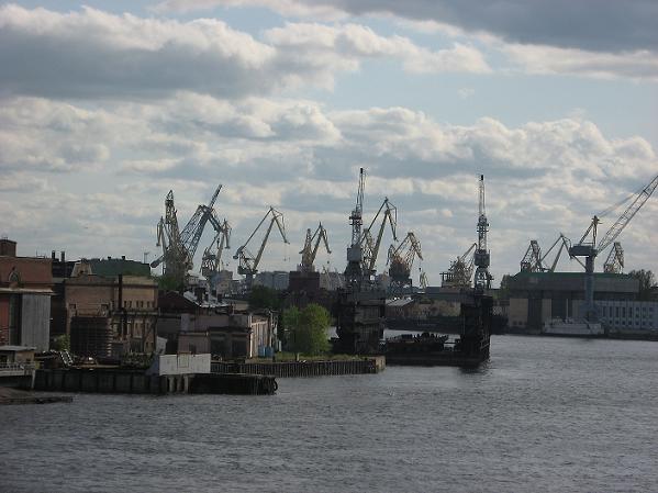
Cranes in the inner freight harbour
I took those photos when the ship left St.Petersburg - with an extra swing towards the first of the bridges that connects the Vasilyevsky Island with the mainland to the south. There had been a thunderstorm in the morning after a hot day before, and towards the evening, the clouds started to let up, though they still were pretty impressive. I liked the surrealistic look of the cranes against the sky.

Annunciation Bridge, with St.Isaac's Cathedral in the background (mainland side)
Above is a view of the Blagoveshchensky Bridge (Annunciation Bridge, for those who don't want to get a knot in their tongue by pronouncing Russian, lol), the first of the bridges that span the Neva, coming from the direction of the Bay of Finland. The second bridge in the background is the Palace Bridge, and the golden cupola belongs to St.Isaac's Cathedral.

Annunciation Bridge, on the Vasilyevsky side
The Annunciation Bridge has been renovated in 2007 when it also got its current name; before it had been known as Lieutenant Schmidt Bridge. Both bridges are drawn up for some hours every night to let transport vessels pass; thus effectively cutting Vasilyevsky Island off the mainland. This can end in a not so nice surprise for those who missed the time to cross; they'll get stuck until about 5 o'clock in the morning.

The Vasilyevsky side of the Neva
The southern embarkment of the river - on the Vasilyevsky side - has some of the oldest houses in St.Petersburg (early 18th century). The canals and streets on this part of the island show a regular, square pattern that indicates a town planned on the drawing board.

The four masted barque Sedov
Another pretty sight was the four-masted square rigged barque STS Sedov; a training ship for cadets of the Russian navy. She was just preparing for a voyage around the world and would leave two days later.

The Sedov against the Vasilyevsly skyline
The ship has an interesting history. She was built in Germany in 1921 as Magdalene Vinnen (later Kommodore Johnsen), a freight carrying sailing ship. After WW2 she came to Russia as war reparation and was renamed Sedov, after the Arctic explorer Georgy Sedov who had died on an expedition in 1914. She served as sail training vessel of the Soviet Navy until 1957, then she was used as an oceanographic research ship until 1966. In the following years, the old lady was only infrequently used until she got overhauled in 1981.

Mary's Annunciation Church on the Vasilyevsky side, seen thrugh the rigs of the Sedov
The Sedov participated in windjammer races during Soviet times and won a number of prices. After the independence of Latvia, she got transfered from Riga (her home since 1982) to Murmansk.
Cranes in the freight harbour
Let's come to some geological details: The Neva is only 74 km long, running from Lake Ladoga to the Gulf of Finland in the Baltic Sea, but its water discharge puts it at place three after the Volga and the Danube. The river is navigable throughout and part of the Volga-Baltic waterway which already the Vikings used.

View over the Neva from the Peter and Paul Fortress
The water flow from Lake Ladoga to the Neva is pretty consistant all year round, so the floods that so often hit St.Petersburg are caused by the inflow of the Baltic Sea during storms. The Neva freezes from December to mid-April, in summer the temperature peaks at 17-20°C.

View from the Stock Exchange place to the Peter and Paul Fortress
The last steps in the formation of the river were the glaciers of the last Ice Age and their retreat which caused the Littorina Sea to form, 7-9 metres above present sea level. A wide strait between the delta and the future Lake Ladoga was covered by water. But the land around the lake rose faster and thus a closed reservoir developed (the race of seal particular to Lake Ladoga is a witness from that time). The rising level of the lake flooded a moraine ridge and ran into the valley at the Ivanovo rapids, the modern Neva with its tributaries Tosna and Mga formed about 2000 BC. The average decline of the river is 4.2 metres.

View from the Stock Exchange to the Palace Embankment
The development of St.Petersburg altered the hydrological network of the delta. The town was founded in 1703. The swampy terrain was not the best place to build a town, but Tsar Peter the Great wanted a Baltic Sea harbour. Tons of earth had to be moved which was used to raise the city; countless timber posts had to be dug into the ground, and canals had to be built for drainage. When the work was completed, the delta of the Neva consisted of 48 canals and rivers, and a hundred islands. Some of the canals were filled in over time so that today only 42 islands remain. A tour through the canals is one of the nicest ways to explore St.Petersburg.

View towards the Eremitage
The area belonged to the realm of Veliky Novgorod, also known as Holmgård in the Norse sagas, since the 9th century; a time when the population was a mix of Slavic and Scandinavian elements, the latter ruling as the Rurikids. Several Norse kings spent a time of exile in Novgorod.
Novgorod had access to the rivers leading south via the river Volkhov / Lake Ilmen, while the route via the Neva / Lake Ladoga went further east; both made Novgorod a trade centre in the Middle Ages. The Hansa League erected their own depedance or kontor, the 'Peterhof', in 1192, thus making the place one of the earliest parts of the rising trade net.

Sunset over the palace embankment
Quarrels and outright war with the Swedes were almost a constant feature of the area. In 1240, Prince Alexander Yaroslavich won a great battle against them which earned him the name Alexander Nevksy; he still features as popular Russian hero. Later, during the Great Northern War 1700-1721, Peter the Great would integrate the lands around the Neva into the Russian Empire and found the town named after him.

White nights at the Neva, with the golden spike of the Admirality in the background
St.Petersburg became the capital of the Russian Empire in 1712. It was renamed Leningrad after the revolution and suffered a devastating siege during WW2 which was only broken in January 1944. After the glasnost, it regained its old name St.Petersburg. But the white nights at the Neva never changed.
¶ July 13, 2012 0 comments
A smaller ship like our cruise ship has a few advantages, among them the fact that the ship could get closer (in)to the towns than the big monsters that have to stay in the larger outer harbours. So she sailed up the Neva to anchor directly in town. That will make for a little series of photos.
I took those photos when the ship left St.Petersburg - with an extra swing towards the first of the bridges that connects the Vasilyevsky Island with the mainland to the south. There had been a thunderstorm in the morning after a hot day before, and towards the evening, the clouds started to let up, though they still were pretty impressive. I liked the surrealistic look of the cranes against the sky.
Above is a view of the Blagoveshchensky Bridge (Annunciation Bridge, for those who don't want to get a knot in their tongue by pronouncing Russian, lol), the first of the bridges that span the Neva, coming from the direction of the Bay of Finland. The second bridge in the background is the Palace Bridge, and the golden cupola belongs to St.Isaac's Cathedral.
The Annunciation Bridge has been renovated in 2007 when it also got its current name; before it had been known as Lieutenant Schmidt Bridge. Both bridges are drawn up for some hours every night to let transport vessels pass; thus effectively cutting Vasilyevsky Island off the mainland. This can end in a not so nice surprise for those who missed the time to cross; they'll get stuck until about 5 o'clock in the morning.
The southern embarkment of the river - on the Vasilyevsky side - has some of the oldest houses in St.Petersburg (early 18th century). The canals and streets on this part of the island show a regular, square pattern that indicates a town planned on the drawing board.
Another pretty sight was the four-masted square rigged barque STS Sedov; a training ship for cadets of the Russian navy. She was just preparing for a voyage around the world and would leave two days later.
The ship has an interesting history. She was built in Germany in 1921 as Magdalene Vinnen (later Kommodore Johnsen), a freight carrying sailing ship. After WW2 she came to Russia as war reparation and was renamed Sedov, after the Arctic explorer Georgy Sedov who had died on an expedition in 1914. She served as sail training vessel of the Soviet Navy until 1957, then she was used as an oceanographic research ship until 1966. In the following years, the old lady was only infrequently used until she got overhauled in 1981.
The Sedov participated in windjammer races during Soviet times and won a number of prices. After the independence of Latvia, she got transfered from Riga (her home since 1982) to Murmansk.
Let's come to some geological details: The Neva is only 74 km long, running from Lake Ladoga to the Gulf of Finland in the Baltic Sea, but its water discharge puts it at place three after the Volga and the Danube. The river is navigable throughout and part of the Volga-Baltic waterway which already the Vikings used.
The water flow from Lake Ladoga to the Neva is pretty consistant all year round, so the floods that so often hit St.Petersburg are caused by the inflow of the Baltic Sea during storms. The Neva freezes from December to mid-April, in summer the temperature peaks at 17-20°C.
The last steps in the formation of the river were the glaciers of the last Ice Age and their retreat which caused the Littorina Sea to form, 7-9 metres above present sea level. A wide strait between the delta and the future Lake Ladoga was covered by water. But the land around the lake rose faster and thus a closed reservoir developed (the race of seal particular to Lake Ladoga is a witness from that time). The rising level of the lake flooded a moraine ridge and ran into the valley at the Ivanovo rapids, the modern Neva with its tributaries Tosna and Mga formed about 2000 BC. The average decline of the river is 4.2 metres.
The development of St.Petersburg altered the hydrological network of the delta. The town was founded in 1703. The swampy terrain was not the best place to build a town, but Tsar Peter the Great wanted a Baltic Sea harbour. Tons of earth had to be moved which was used to raise the city; countless timber posts had to be dug into the ground, and canals had to be built for drainage. When the work was completed, the delta of the Neva consisted of 48 canals and rivers, and a hundred islands. Some of the canals were filled in over time so that today only 42 islands remain. A tour through the canals is one of the nicest ways to explore St.Petersburg.
The area belonged to the realm of Veliky Novgorod, also known as Holmgård in the Norse sagas, since the 9th century; a time when the population was a mix of Slavic and Scandinavian elements, the latter ruling as the Rurikids. Several Norse kings spent a time of exile in Novgorod.
Novgorod had access to the rivers leading south via the river Volkhov / Lake Ilmen, while the route via the Neva / Lake Ladoga went further east; both made Novgorod a trade centre in the Middle Ages. The Hansa League erected their own depedance or kontor, the 'Peterhof', in 1192, thus making the place one of the earliest parts of the rising trade net.
Quarrels and outright war with the Swedes were almost a constant feature of the area. In 1240, Prince Alexander Yaroslavich won a great battle against them which earned him the name Alexander Nevksy; he still features as popular Russian hero. Later, during the Great Northern War 1700-1721, Peter the Great would integrate the lands around the Neva into the Russian Empire and found the town named after him.
St.Petersburg became the capital of the Russian Empire in 1712. It was renamed Leningrad after the revolution and suffered a devastating siege during WW2 which was only broken in January 1944. After the glasnost, it regained its old name St.Petersburg. But the white nights at the Neva never changed.
¶ July 13, 2012 0 comments
30 Jun 2012
I'm Back Online
After a good deal of fiddling with cables - I'm not good at deciphering the odd glyphs that come with manuals these days - and trying to find the places where to type in the starter code and other information, both my computer and the laptop are back communicating with the net, and the phone works as well.
So I can go back to the usual work, but for now I'll leave you with some lovely pics of the Kiel Canal in the evening.

The Kiel Canal in the evening
It's way too hot here, and in the evenings we get the usual thunderstorms. This is going to develop into the typical German summer of heat, thunderstorms, rain, cool weather, hot again, thunderstorms ..... We've been through that the last two years as well.

Another view past sunset
I'm hunting down some reliable information about the Kiel Canal for a post, since I have so many photos of that one - it takes about 8 hours to cross it and there were plenty of views - not to mention the lock at Kiel-Holtenau we passed on the way to the Baltic Sea in the morning after we'd been traveling through the canal during the night.
¶ June 30, 2012 3 comments
After a good deal of fiddling with cables - I'm not good at deciphering the odd glyphs that come with manuals these days - and trying to find the places where to type in the starter code and other information, both my computer and the laptop are back communicating with the net, and the phone works as well.
So I can go back to the usual work, but for now I'll leave you with some lovely pics of the Kiel Canal in the evening.
It's way too hot here, and in the evenings we get the usual thunderstorms. This is going to develop into the typical German summer of heat, thunderstorms, rain, cool weather, hot again, thunderstorms ..... We've been through that the last two years as well.
I'm hunting down some reliable information about the Kiel Canal for a post, since I have so many photos of that one - it takes about 8 hours to cross it and there were plenty of views - not to mention the lock at Kiel-Holtenau we passed on the way to the Baltic Sea in the morning after we'd been traveling through the canal during the night.
¶ June 30, 2012 3 comments
11 Jun 2012
Raised Bog in the Solling-Vogler Nature Park
The weather didn't play nice last week, raining on the Queen's jubilee and generally making a nuisance of itself. Though around here the trees and plants needed the water; it had been very dry. Still, it's a good reason to post some sunny photos.

Timber trackway in the Mecklenbruch bog
The Solling-Vogler Nature Park lies to the north-west of Göttingen, stretching down to the Weser river. The other Nature/National Park I've been posting about several times, the Harz, is to the north-east. The mountains in the Solling are gentler than the highest Harz ones, but both landscapes belong to the German mittelgebirge (another word the English language snagged out of our pocket, it seems).

A tower for a better overview
The name Mecklenbruch likely developed from a Old Saxon Mekelenbroik, meaning 'large swamp.' The area was first mentioned in a charte from 1575. Since 1800, the peat was used to fire the glass making furnaces; later, drainage canals were added and the bog almost destroyed.

View from the tower over the bog
The Mecklenbruch bog encompasses 63 hectares; only a small part of it is accessible via the timber trackway, the rest is left free of any human influence. A project to undo the human-made changes is going on since the 1980ies, and the bog stands a good chance to survive, though it will take several decennies for it to regain its former nature.

View from the tower, different angle
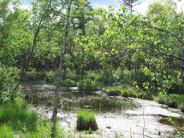
A raised bog needs a cool and wet (minimum of 800 mm rain per annum) climate to develop, because raised bogs don't have any contact to groundwater. The second requirement is an acidic substrate that's impermeable to water - in case of the Mecklenbruch that is provided by a layer of weathered sandstone and loess that developed during the last Ice Age. Raised bogs are also called ombrotrophic (rain-fed).

View to the trackway
And that's how it works. What started out as lake would over time turn into a marsh, then fen, carr (a peat or silt filled lake; see photo below) and eventually a bog. Sphagnum mosses will settle on the saturated ground; they can take up 20-30 times their own dry weight in water. While their lower part slowly decays and turns into peat, the moss layer grows in height, eventually raising the ground beyond groundwater level. At that point, we call it a raised bog. It took 4500 years for a 5 metres high peat layer to develop under those conditions.
A carr in the Mecklenbruch bog
Thus the centre of an ombotrohpic bog is a treeless dome with true bog conditions, while strips of fen, carrs, and wetland vegetation (moor birches, Norway spruces and shrubs) are found in the outskirts. Those areas may be reached by groundwater. The trackway in the Mecklenburch bog leads through that sort of terrain for the most; the true bog can best be seen from the tower.

A little lake
There are similar raised bogs in the Harz, and most of those are not accessible to the public, either. The Harz had another problem that endangered the bogs: the waterworks needed for mountaineering (esp. silver). There is a whole system of artificial lakes that would provide water power to wash ore out of the stone. That system today is a Cultural Heritage; the Oderteich is part of it.

Some drama queen clouds
The clouds on the last photo looked very dramatic, but they didn't pose any real threat; the day remained fine and dry.
Below are some more photos.

The raised bog in August
You can see that on the fringes, the bog turns into a swamp with more shrubs and trees that tolerate watery surroundings, and no more sphagnum mosses.

The heather in bloom
While the first potos were taken in spring, I took another tour in August when the heather was in bloom.

A bog pond
The next time I returned to the Meckelnbruch was an autumn afternoon. The atmosphere was pretty different though it was a sunny day as well.

A view from the tower
Somehow, autumn fits bogs and moors even better than late spring. The colours were just lovely, all those shades of yellow and brown, and a deep blue sky mirroring in the dark lakes.

Another view, to the other side
The bog is the home of a number of endangered flora (fe. sundew, a sort of cranberry - Vaccinium oxycoccus) and fauna (dragonflies), though I didn't manage to catch any of those pretties on the camera (and the sundew is in the inaccessible part of the bog).

The timber trackway

One of several little lakes
I took those photos in late October.

The carr in a hazy autumn sun

A stand of young birches

Mecklenbruch Bog / Solling in autumn
¶ June 11, 2012 3 comments
The weather didn't play nice last week, raining on the Queen's jubilee and generally making a nuisance of itself. Though around here the trees and plants needed the water; it had been very dry. Still, it's a good reason to post some sunny photos.
The Solling-Vogler Nature Park lies to the north-west of Göttingen, stretching down to the Weser river. The other Nature/National Park I've been posting about several times, the Harz, is to the north-east. The mountains in the Solling are gentler than the highest Harz ones, but both landscapes belong to the German mittelgebirge (another word the English language snagged out of our pocket, it seems).
The name Mecklenbruch likely developed from a Old Saxon Mekelenbroik, meaning 'large swamp.' The area was first mentioned in a charte from 1575. Since 1800, the peat was used to fire the glass making furnaces; later, drainage canals were added and the bog almost destroyed.
The Mecklenbruch bog encompasses 63 hectares; only a small part of it is accessible via the timber trackway, the rest is left free of any human influence. A project to undo the human-made changes is going on since the 1980ies, and the bog stands a good chance to survive, though it will take several decennies for it to regain its former nature.
A raised bog needs a cool and wet (minimum of 800 mm rain per annum) climate to develop, because raised bogs don't have any contact to groundwater. The second requirement is an acidic substrate that's impermeable to water - in case of the Mecklenbruch that is provided by a layer of weathered sandstone and loess that developed during the last Ice Age. Raised bogs are also called ombrotrophic (rain-fed).
And that's how it works. What started out as lake would over time turn into a marsh, then fen, carr (a peat or silt filled lake; see photo below) and eventually a bog. Sphagnum mosses will settle on the saturated ground; they can take up 20-30 times their own dry weight in water. While their lower part slowly decays and turns into peat, the moss layer grows in height, eventually raising the ground beyond groundwater level. At that point, we call it a raised bog. It took 4500 years for a 5 metres high peat layer to develop under those conditions.
Thus the centre of an ombotrohpic bog is a treeless dome with true bog conditions, while strips of fen, carrs, and wetland vegetation (moor birches, Norway spruces and shrubs) are found in the outskirts. Those areas may be reached by groundwater. The trackway in the Mecklenburch bog leads through that sort of terrain for the most; the true bog can best be seen from the tower.
There are similar raised bogs in the Harz, and most of those are not accessible to the public, either. The Harz had another problem that endangered the bogs: the waterworks needed for mountaineering (esp. silver). There is a whole system of artificial lakes that would provide water power to wash ore out of the stone. That system today is a Cultural Heritage; the Oderteich is part of it.
The clouds on the last photo looked very dramatic, but they didn't pose any real threat; the day remained fine and dry.
Below are some more photos.
You can see that on the fringes, the bog turns into a swamp with more shrubs and trees that tolerate watery surroundings, and no more sphagnum mosses.
While the first potos were taken in spring, I took another tour in August when the heather was in bloom.
The next time I returned to the Meckelnbruch was an autumn afternoon. The atmosphere was pretty different though it was a sunny day as well.
Somehow, autumn fits bogs and moors even better than late spring. The colours were just lovely, all those shades of yellow and brown, and a deep blue sky mirroring in the dark lakes.
The bog is the home of a number of endangered flora (fe. sundew, a sort of cranberry - Vaccinium oxycoccus) and fauna (dragonflies), though I didn't manage to catch any of those pretties on the camera (and the sundew is in the inaccessible part of the bog).
I took those photos in late October.
¶ June 11, 2012 3 comments
25 May 2012
A Baltic Sea Cruise
I'm back from my cruise which took place on a smaller ship than the usual monsters (800 passengers maximum) and therefore was a lot more fun for me. As usual, I got a truckload of photos. So here's the traditional overview post of the places I've visited.
Visby and Gotland's west coast (Sweden)
A Medieaval town that belonged to the Hanseatic League and to the Gotland Trade League before, with some well conserved town fortifications, a cathedral, nice old houses (trade made for rich merchants who in turn built pretty houses to show off), and a few ruins.

Visby, the town walls
I took a bus tour along part of the west coast of Gotland so I could catch some impressions of the landscape, too. We had some interesting stops; one of them the ship setting at Gnisvärd. The flip side to guided tours are the other people in the group, but I managed to keep their appearance on photos to a minimum.

Bronze Age ship setting
Stockholm, and Stockholm Archipelago
I've lived there back in the 80ies. It was nice to revisit the place. The sun played along, too, as it did most of the tour. No grey and stormy Baltic Sea photos, I'm afraid. Well, we got some of those along the Norwegian coast last year.

Stockholm, the town hall
One place was new to me; the Vasa Museum where Gustav Adolf's flagship, which had sunk in Stockholm harbour in 1628 and was resurrected in the 1950ies, is now displayed in full splendour after years of conservation and reconstruction work.

The Vasa
Our ship cruised the archipelago in the evening which made for some great motives There are about 2400 islands of all sizes from several square miles to 'just a boulder with a fir tree', and on the larger ones, many Swedes have summer houses.

Romantic islands in the evening sun
Helsinki and Porvoo (Finland)
Helsinki is a rather young town, compared to places like Visby, but there was a tour to nearby Porvoo, a small Mediaeval town with pretty timber houses which, albeit not exactly Mediaeval (those had a habit of burning down during history), give the place an old fashioned, charming flair.

Helsinki Cathedral
St.Petersburg (Russia)
We stayed in St.Petersburg for two days. It's the time of the white nights now when it doesn't get fully dark, but twilight remains. It was unusually warm, too. Petersburg is a town of cathedrals with golden cupolas, splendid palaces, kitch vendors, and cars. I bet London has nothing to the chaos on the roads in St.Petersburg.

Church of Christ's Resurrection
The town is also bascially built on a swamp by Peter the Great, and it's a place with a history of assassinations. The above church was erected on the spot where Tsar Alexander I got killed, and Tsar Paul wasn't safe in his pretty palace below, either. I took an evening cruise on the many canals that cut through Petersburg which was a nice change to the road traffic. Here are some impressions from the Neva.

Palace of Tsar Paul
Tallinn (Estonia)
Another Hanseatic town, known as Reval when most of the territory of todays Baltic States was in the hands of the German Hanseatic League and the Teutonic Knights.

Tallinn, view from the Upper Town to the Old Town
Riga (Latvia)
Another member of the Hanesatic League. It is amazing how fast those towns managed to repair their historical sites that often had been damaged or destroyed during WW2 and neglected during the Sovjet area. Tallinn, Riga and Gdansk all have World Heritage status today. And the beer is still cheaper than in Germany. *grin*

Riga, House of the Black Brotherhood
Curonian Spit and Nida (Lithuania)
The Curonian Spit (Kurische Nehrung) is a 98 km long dune spit that separates the Curonian Lagoon from the Baltic Sea. To prevent the dunes from covering everything, a reforesting program had been established in the 19th century, and today there are birch and pine woods, but still a lot of sand, too.
The Geat Dune
And some pretty villages like Nida (formerly Nidden) which had been a summer residence of rich Germans post WW2. The writer Thomas Mann spent some time there, and it would still make a good writer's retreat today; the place is very quiet, with the lagoon on one side and only a mile or so to the Baltic Sea.

A fisherman's hut in Nida
Gdańsk and Malbork Castle (Poland)
Gdańsk is another town with a great Hanseatic tradition and lots of beautiful old houses as well as an interesting cathedral. It's also a centre of amber working and amber trade, in good Medieaval tradition when amber was one of its main export articles. Yes, I got me a bracelet.

Gabled houses in Gdańsk
Amber trade was in the hands of the Teutonic Knights, and boy, did they build a whopping big castle a bit inland. Sorry, Edward I, but your Welsh castles have nothing to the Marienburg (Malbork Castle). I was lucky to be able to spend several hours there, exploring at least part of it.

Marienburg (Malbork) Castle, middle and inner bailey
Kiel Canal (Germany)
Better know as Nord-Ostsee-Kanal in Germany. Since our ship sailed off from Bremerhaven at the North Sea, we had to cross the canal to get to the Baltic Sea (it's much shorter than rounding the entire peninsula), and on the way back it took place mostly during daylight. It was almost like a river cruise.

Traffic on the Kiel Canal
Bremen (Germany)
On the way back, I stopped in Bremen for a few hours, to add another Hanseatic town to my collection. Its Renaissance town hall is one of the most beautiful in Europe, and there's a cathedral and some narrow streets with old houses as well.

Bremen, the town hall
Blog fodder for months to come, and I haven't even finished all posts about the Welsh castles from 2008. *sigh*
¶ May 25, 2012 4 comments
I'm back from my cruise which took place on a smaller ship than the usual monsters (800 passengers maximum) and therefore was a lot more fun for me. As usual, I got a truckload of photos. So here's the traditional overview post of the places I've visited.
Visby and Gotland's west coast (Sweden)
A Medieaval town that belonged to the Hanseatic League and to the Gotland Trade League before, with some well conserved town fortifications, a cathedral, nice old houses (trade made for rich merchants who in turn built pretty houses to show off), and a few ruins.
I took a bus tour along part of the west coast of Gotland so I could catch some impressions of the landscape, too. We had some interesting stops; one of them the ship setting at Gnisvärd. The flip side to guided tours are the other people in the group, but I managed to keep their appearance on photos to a minimum.
Stockholm, and Stockholm Archipelago
I've lived there back in the 80ies. It was nice to revisit the place. The sun played along, too, as it did most of the tour. No grey and stormy Baltic Sea photos, I'm afraid. Well, we got some of those along the Norwegian coast last year.
One place was new to me; the Vasa Museum where Gustav Adolf's flagship, which had sunk in Stockholm harbour in 1628 and was resurrected in the 1950ies, is now displayed in full splendour after years of conservation and reconstruction work.
Our ship cruised the archipelago in the evening which made for some great motives There are about 2400 islands of all sizes from several square miles to 'just a boulder with a fir tree', and on the larger ones, many Swedes have summer houses.
Helsinki and Porvoo (Finland)
Helsinki is a rather young town, compared to places like Visby, but there was a tour to nearby Porvoo, a small Mediaeval town with pretty timber houses which, albeit not exactly Mediaeval (those had a habit of burning down during history), give the place an old fashioned, charming flair.
St.Petersburg (Russia)
We stayed in St.Petersburg for two days. It's the time of the white nights now when it doesn't get fully dark, but twilight remains. It was unusually warm, too. Petersburg is a town of cathedrals with golden cupolas, splendid palaces, kitch vendors, and cars. I bet London has nothing to the chaos on the roads in St.Petersburg.
The town is also bascially built on a swamp by Peter the Great, and it's a place with a history of assassinations. The above church was erected on the spot where Tsar Alexander I got killed, and Tsar Paul wasn't safe in his pretty palace below, either. I took an evening cruise on the many canals that cut through Petersburg which was a nice change to the road traffic. Here are some impressions from the Neva.
Tallinn (Estonia)
Another Hanseatic town, known as Reval when most of the territory of todays Baltic States was in the hands of the German Hanseatic League and the Teutonic Knights.
Riga (Latvia)
Another member of the Hanesatic League. It is amazing how fast those towns managed to repair their historical sites that often had been damaged or destroyed during WW2 and neglected during the Sovjet area. Tallinn, Riga and Gdansk all have World Heritage status today. And the beer is still cheaper than in Germany. *grin*
Curonian Spit and Nida (Lithuania)
The Curonian Spit (Kurische Nehrung) is a 98 km long dune spit that separates the Curonian Lagoon from the Baltic Sea. To prevent the dunes from covering everything, a reforesting program had been established in the 19th century, and today there are birch and pine woods, but still a lot of sand, too.
And some pretty villages like Nida (formerly Nidden) which had been a summer residence of rich Germans post WW2. The writer Thomas Mann spent some time there, and it would still make a good writer's retreat today; the place is very quiet, with the lagoon on one side and only a mile or so to the Baltic Sea.
Gdańsk and Malbork Castle (Poland)
Gdańsk is another town with a great Hanseatic tradition and lots of beautiful old houses as well as an interesting cathedral. It's also a centre of amber working and amber trade, in good Medieaval tradition when amber was one of its main export articles. Yes, I got me a bracelet.
Amber trade was in the hands of the Teutonic Knights, and boy, did they build a whopping big castle a bit inland. Sorry, Edward I, but your Welsh castles have nothing to the Marienburg (Malbork Castle). I was lucky to be able to spend several hours there, exploring at least part of it.
Kiel Canal (Germany)
Better know as Nord-Ostsee-Kanal in Germany. Since our ship sailed off from Bremerhaven at the North Sea, we had to cross the canal to get to the Baltic Sea (it's much shorter than rounding the entire peninsula), and on the way back it took place mostly during daylight. It was almost like a river cruise.
Bremen (Germany)
On the way back, I stopped in Bremen for a few hours, to add another Hanseatic town to my collection. Its Renaissance town hall is one of the most beautiful in Europe, and there's a cathedral and some narrow streets with old houses as well.
Blog fodder for months to come, and I haven't even finished all posts about the Welsh castles from 2008. *sigh*
¶ May 25, 2012 4 comments