My Travel and History Blog, Focussing mostly on Roman and Mediaeval Times
Oops, it has happened again. I could not find a lot more information about the Keukenhof Park beyond what I posted in the introductory post about my tour to the Netherlands, but I fell into a research hole about the Bavarian Counts of Holland-Zeeland and Hainaut. Instead of a post with lots of photos and little text, this will be a post with a fair amount of history and some photos. Well, you can always just look at the tulips. ;) Though the park looked nothing like today when Count Willem IV or Jacoba of Bavaria-Holland hunted there.

Keukenhof means 'kitchen garden' and was part of a hunting ground that belonged to the owners of Castle Teylingen. The castle had been built to protect a major south-north going route in the province Holland, and was in possession of the counts of Holland. The first documented owner was Count Willem IV (1307-1345). But it would be one of his successors who is most famously connected with the castle and the park at Keukenhof: Jacoba (English: Jacqueline, German: Jakobäa; 1401-1436) of the Bavarian House Wittelsbach, Countess of Holland, Zeeland and Hainaut. She was an interesting character; obviously a woman with a mind of her own, though in the end she could not survive politically in a male-dominated world. She remains quite popular in the Netherlands, not the least due to her four marriages.
Read more »
… and a little bit of Belgium. The Netherlands got plenty of rivers, canals of various sizes, and lakes, therefore a tour by boat will get you to a fair number of places in ten days. This 'Back with Booty' post will include not only tulips and windmills, but also several charming Dutch towns – most of them with canals – and some other sights like cathedrals and harbour impressions.
The weather was a mixed affair, including everything from below 10°C with rain and lots of wind to balmy 20°C and sunshine. Sometimes changing within a single day. I had to tamper with some of the photos that had ended up on the Dark Side.

The tour started in Cologne in Germay. I arrived a day early so I could visit the High Cathedral Church at Cologne, as it is officially called (short: Kölner Dom). It is a landmark of Gothic architecture, the tallest twin spired church in the world (157 m / 515 ft), a World Heritage site since 1996, and one of the most visited places in Germany – esp. on an Easter weekend when pilgrims join the tourists.
Read more »
I had intended to write a post about the history of Havelberg, a town on the eastern bank of the Elbe river. Its landmark, the cathedral situated on a moraine hill, dates back to the 10th century, though the present building was erected in the 13th century on older remains from 1170.
But then I fell down a research rabbit hole deep enough to hide a balrog, about the German expansion east of the Elbe and the Slavic tribes that lived there. So this post will mostly be about those events in form of an overview, with spotlights on some particularly interesting and better documented events. The entire history, as usual, was more complicated, but my blog is not a thesis paper, albeit it turned out the first more deeply researched post I've written since 2020.

(photo taken in the open air museum Gross-Raden near Schwerin)
The landscape north of the central uplands (the Harz being the northernmost mountain range) is a terminal moraine landscape shaped by the Ice Ages. It is flat to hilly – though those hills are seldom higher than a hundred metres –, with river deltas, many lakes, forests and bogs. The lakes and bogs provided defenses; the ground was fertile once cleared, the coast offered fishing and trade contacts. Further south-east (fe. Bohemia), the land was part of the central uplands. Settlements were spread out, and it was not so easy to invade the land with a large host due to the rivers (as we will see below), bogs, and woods.
By the 10th century, the lands east of the Elbe all the way to the Oder and the Baltic Sea were settled by tribes that – as far as we can judge by sources, archaeological finds, place names and such – spoke languages of the Slavic family and likely shared some cultural and religious mores (1).
I did a little tour to the Altmark in September 2022. Got to photograph some pretty Romanesque and Gothic brick architecture, and found a lovely little town, Tangermünde, which is still somewhat flowing beneath the tourist radar. It was my second visit to the Altmark, I’d already been there in 2016.
This is one of the posts mentioned below that I'm going to rewrite (as I did here). The original was but a collection of six photos with no text, which is not what I usually do on this blog.
Tangermünde – situated on a plateau at the confluence of the Tanger river into the Elbe – is first mentioned in the chronicle of Thietmar von Mersebug in the year 1009. There was a castle to protect the river crossing which soon attracted a settlement. The market town Tangermünde is first mentioned in a charte dating to 1275. Read more »
The few regular readers I still have may have noticed some – albeit minor – changes to the blog. I would really like to give it a more modern look, but all the new templates don’t accept my sidebar which is not date or keyword based, but more like a table of contents. And it is very important for the blog, so I’ll stick to the old template where I can hand-code everything. I only tried to make it look a bit cleaner and lighter.
The other point I wanted to change is the long posts you’ll have to scroll past to find the next one. New templates usually take care of that, but poor me found only one solution: Go to every blasted post and insert the ‚Read More‘ code by hand. I had close to 500 posts, since I wrote more but shorter posts during the first years of my 20 years of blogging. But the result looks better and easier to navigate.

I took the chance to delete some posts that were not conveying any information, and merge a number of shorter posts about the same topic, overall bringing the total amount of under 400. Which is still a lot, and some posts are in need of a rewrite, and some older photos are in need of editing.
I did a bit of that during the cleanup process, but there are more posts to which I should go back and edit photos and text. If the changes are significant, I will repost those as new posts.
I’ve not much experience photographing animals since I seldom have the chance, but when I was in Bremerhaven (on the way to Norway), the local zoo was close to my hotel and thus I visited. I did not manage to take photos of all the species – they are often under water, in the retirement areas, or just too fast to catch on camera –, but I got a collection of ok-ish photos of some of them.

The Zoo am Meer (Zoo by the Sea) in Bremerhaven, situated at the Weser estuary close to the North Sea, is a rather small zoo, with a basis ground of only 8,600 m2 that by the clever mountain-like architecture was expanded to 11,800 square metres, and focusses – mostly – on animals from the polar regions. The zoo is part of the World Association of Zoos and Aquaria. Read more »
Another journey, or rather, voyage this year was to Norway via Bremerhaven in Germany. I had traveled along the coast of Norway on the Hurtigruten Tour in 2011, but most of the fjords aren’t part of the tour (and Geiranger is not called at due to ice and avalanches). This voyage – on a smaller ship, not one of those 6,000 passenger monsters – concentrated on the fjords of south-western Norway. Bus tours to some of the most scenic sites were offered while the ship was at anchor. In for some spectacular Norwegian landscape? *grin*

We start with one of the many waterfalls. This was on a tour from Bergen to Øystese at the Hardangerfjord, across the Eikedalen/Kvamskogen area popular for its skiing resorts. It’s not always possible to take photos out of the moving bus, but besides the longer official stops, the driver added a few what he called 'Japanese stops' ("five minutes for photos and don’t dither"). Read more »
An overcast spring day in early May may not be the perfect time to visit a garden in cold and windy Denmark, but I nevertheless got a good amount of photos of fresh spring greens and lovely flowers, mostly tulips and rhododendron, when I visited Egeskov Castle and the large park. A lot of flowers like roses, dahlias, fuchsias and others, will only bloom later in summer. But there’s one advantage to visiting rather early in the year – less tourists who cluster around the flowerbeds.

I wrote a short version of the history of Egeskov Castle included in this blog post Egeskov Castle as we – mostly – can see today, was built in 1554 by the Danish nobleman Frands Mikkelsen Brockenhuus (1518-1569), military leader, diplomat, and member of the Royal Council, though an older building on the grounds is mentioned in 1405. Brockenhuus bought adjacent land and added the first park around the castle. Read more »
Here is the second part of my Back with Booty posts from Denmark (the first can be found here). 15 days won’t cover the country – even leaving out Copenhagen and surroundings which I visited years ago – but proved sufficient to see quite a few interesting places.

Odense is another town whose origins go back way into the past. The first time the name appears is a charte in which the German Emperor Otto III granted rights (unspecified; have to research that for future posts) to Odense in 988, but archaeological finds go beyond that. Odense had been a Viking settlement – one of Harald Bluetooth’s ring fortresses was buit here – though that past is mostly hidden under the present town. Read more »
This year I went to hunt some Vikings and pretty Danish towns. Here’s the usual Back with Booty-post. I started this blog in May 2005, so it’s the 20 year anniversary of The Lost Fort. A good reason for picture fun, after all.

The Danes love their flag, the Dannebrog; you’ll find it flying pretty much everywhere. Read more »
I’ve decided to participate in the annual Photo Parade (Fotoparade) on Michael’s blog Erkunde die Welt (Discover the World) again. My post from last year’s parade can be found here.
Michael offers several key words every year, so I’ve tried to find some photos for the categories 2024 from the collection of my tour to Latvia, Estonia and Helsinki (plus Kiel again upon return) in spring.
Category: Architecture (Architektur)

The State Museum for Ethnology, presenting historical houses relocated from the county of Schleswig Holstein, in Molfesee near Kiel has recently openend its new entrance and exhibition area. It consists of two houses with a cladding of corten steel which imitate the form of historical houses and barns with their high roofs (which are usually thatched with reed). Read more »
Helsinki also offered the chance for a day trip. Turku, the oldest town in Finland, is only about two hours bus ride away, and a nice ride through an interesting landscape it is, too. I put it in this post because the other post got too long already.

For a long time. Turku had been a Swedish town (Ǻbo), because Finland had been part of the Kingdom of Sweden. The town developed along the river Aura in the 13th century. When Finland became a Grand Duchy of the Russian Empire in 1809, Turku was its capital, but a few years later Tsar Alexander I moved the capital to Helsinki with its fortress Sveaborg/Suomenlinna. Read more »
This year I wanted to complete the tour of the Baltic States, and since it’s only two hours by ferry from Tallinn to Helsinki, I decided to add a bit of Finland to the list. I enjoyed three weeks of mostly sunshine and temperatures unusually warm to hot for the countries so far north. The Fins were shaking their heads at +28 °C in late May; they are more used to about 15 °C and rain. There are also those lovely long and still bright evenings of the North I remembered from my time in Stockholm.

I started my tour with Riga in Latvia. I had visited the town during the Baltic Sea Cruise in 2012, but while there was reasonable time to see the most important sites, it was not enough for the less touristy places and also, there were still buildings undergoing renovation. Read more »
A bit of fun at the beginning of the new year. I’m following several German travel blogs, and that way came across the annual Photo Parade (Fotoparade) on Michael’s blog Erkunde die Welt (Discover the World). He’s been doing it for several years now, and the replies of the contributors have offered a whole bunch of new blogs for me to browse. Michael offers several key words every year, and you should try to find photos – taken in that year – that match the categories. Here’s my try:
Category: Landscape (Landschaft)

The Curonian Spit is one of my favourite landscapes in Lithuania, so it’s no wonder I took the chance for another visit of a different part of the spit; this time near Juodkrantė. It was a warm, sunny day with some wind going that created pretty waves on the Baltic Sea. I walked some distance along the shore and returned through the pine forest to the lagoon side of the spit, to catch the ferry back to Klaipeda. Read more »
The highlight of the tour was Vilnius, of course. There will be more detailed posts (I got enough photos, lol), so here’s just a little teaser.

Vilnius is a town of churches, Roman-Catholic, Orthodox, and a few Protestant ones. Most of them have been altered at a time when the Baroque flourished in Lithuania, but there are some Gothic ones as well, and others keep traces of older architecture. Read more »
It’s quite some time we last had a real Back with Booty post due to that Evil C and some private reasons. But this year I did a longer tour outside Germany and spent two weeks in Lithuania.

One way to get to Lithuania is to take the ferry from Kiel to Klaipeda, so Klaipeda (formerly the German Memel) was my first stop on the way. Read more »
I’ve mentioned the German spa town Bad Sooden-Allendorf at the Werra in my post about the Bruchteiche reservoir and already told a bit about its history and the geological foundations of the salt deposits. I recently visited the town itself and collected a whole bunch of photos of half-timbered houses ‒ Bad Sooden-Alledorf is famous for those ‒ and the fascinating history and processes of salt destillation by graduation towers for you.

The town was badly destroyed during the Thirty Years War (1618‒1648), so almost all of the houses in the old town of Allendorf date to the 17th century, which gives Bad Sooden-Allendorf an unusually harmonic look. The style of the houses is a mix of the local half-timbering traditions of Hessia, Thuringa, Lower Saxony and even Franconia, since the craftsmen hailed from various districts, yet forming a coherent whole; one could almost call it the Allendorf style. :) Read more »
It was more or less a flyby visit to Treffurt on our way back from Normanstein Castle. We wanted some tea and a piece of cake, so we went down to the little town of Treffurt – and found a charming place of old houses and narrow lanes; quite Mediaeval in part. (1)

The old town of Treffurt brings you back in time: the pavement is mosty cobblestones, some lanes are too narrow for modern cars, and some of them are rather steep because the town ascends part of the Normanstein mountain − it was a safer terrain than the Werra shores which tend to get flooded in spring. Read more »
The town of Stralsund was one of the leading members of the Hanseatic League and thus one of the few German towns that still carry the denomination in official documents ‒ Hansestadt Stralsund. The historical buildings in the old town are so well preserved and/or have been painstaikingly restored that Stralsund, together with Wismar, became a UNESCO World Heritage Site in 2002. There are lots of pretty Mediaeval and Renaissance brick buildings, so let's go for a little walk through the old town of Stralsund.
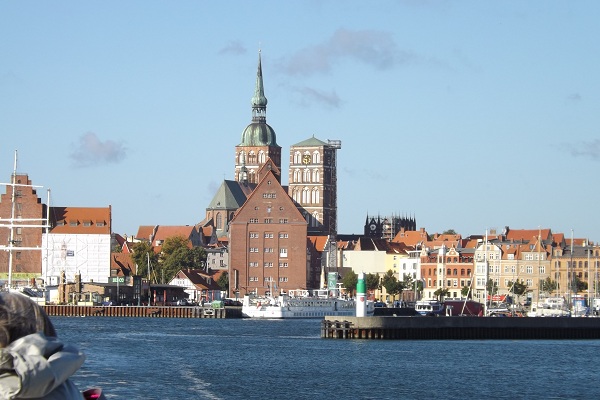
I've already posted about the harbour of Stralsund; we'll start our virtual tour the same way most merchants once did, coming in by ship.
Stralsund lies on the mainland opposite the island of Rugia (Rügen). Rugia was settled by the Slavic tribe of the Rani, still pagans at the time they were conquered by King Valdemar I of Denmark in 1168. Their princes became vassals to Valdemar and accepted the Christian faith. They extended their territory to the mainland: Fishing villages on the Dänholm Isle between the mainland and Rugia, and on the mainland itself, grew in imporance, became harbours for the Danish fleet and a trade hub. Settlers were invited; many of them came from Germany, bringing with them German technology and culture, soon dominating the burgeoning settlement of Stralov, later to be named Stral(e)sund. Read more »
Neolithic Tombs can be found in various locations in northern Germany. I've already posted about the historical context and some finds here. Another group of tombs can be found in the 'Burial Site' (Totenstatt) near Oldendorf/Luhe (not far from Amelinghausen) in the Lüneburg Heath. Of course, I couldn't resist adding more big ol' stones to my collection.

The most visible feature of the Burial Town are the late Neolithic stone tombs (known as hunebeds or dolmen), but there are more burials from other times still mostly hidden under the layer of earth, heather and trees. A number of Bronze Age tumuli (1600 – 1200 BCE) spread between the large tombs have not yet been researched – some of them are visible as flat stone circles hidden in the heather – and there are also several urn grave fields from the Iron Age and Migration Period, as well as burials from the Mesolithic. Overall, the site has been in use for 4,000 years. Read more »
I finally managed to get in a few days of travelling this year – still in Germany, due to Corona. I chose the Lüneburg Heath (Lüneburger Heide), an area between Hamburg and Hannover that still has stretches of various heath landscapes, most of them protected nature reseves.

The weather was ideal for hiking, moderate temperatures and an overcast sky, though the latter unfortunately makes for less pretty photos – heather in the sunshine looks more lovely on pictures. The peak of the heath bloom is over by mid-September, though some of itl is still in flower. Read more »
This year, I didn't plant any geraniums and marguerites as usual, but decided for a 'bee friendly seed mix'. It turned out quite well; there are new flowers popping up every few days.

There had been a rain shower right before; the drops lend an extra sparkle to the flowers. Read more »
Once upon a time, god and the devil decided to divide the world between them. The devil should get all the land he could wall in during one night. So the devil set off from the north and all went nicely at first. But an old woman was walking down the Harz mountains with a cock she wanted to sell at the market. Since the way was long, she had started off in the middle of the night. She stumbled in the darkness, and the cock awoke and let off a merry cock-a-doodle-doo. The devil thought dawn was approaching and, taken with ire, he smote the wall he had built.

Parts of the cracked wall – known as Devil's Wall (Teufelsmauer) – can still be seen between Ballenstedt, from where it runs for about 20 km in north-western direction to Weddersleben (near Quedlinburg) and Blankenburg. Geologically, the formation stretches all the way to Goslar where it reappears as the Klus Rock. Read more »
Just a summer photo post today. I still got a number of pretty photos from my Rugia tour in my files.

I've posted about the seaside ressort Binz here, but got more photos of the beach and the pier. Read more »
I mentioned the Mediaeval ringwall and the Bronze Age burial mounds in my post about the Bruchteiche. Those sites are hidden in the forest which makes for another pretty Summer-in-Germany post with a bit of cool shade during the hot days we just got.

There is a substantial number of fortifications in Germany dating to the Iron Age or the early Mediaeval period. Most of them are scarcely visible today, often located on forested hills or promontories where they look like natural structures at first view. They are known as ringwall forts or walled castles, like so so-called Römerlager ('Roman Camp', though it has nothing to do with the Romans) near Bad Sooden-Allendorf. Read more »
My hotel in Weimar was close to one of the entrances to the Park at the Ilm, so I decided for an afternoon walk upon my arrival. First, I went straight to Goethe's garden house in order not to miss the opening hours (it will get its own post), but afterwards I just strolled through the park without a list of things to see., But I came across some of the famous features like the Roman House and the artificial ruin nevertheless.
Come with me on a lovely walk.

The Park at the Ilm was mostly a wilderness when Goethe arrived in Weimar in 1775. The garden house or cottage he received from the duke was a former vintner house, though the vintage was long defunct; most of what grew on the slope were fruit trees in need of pruning, and some vegetables. Read more »
When I traveled to Erfurt in 2017, I not only collected some more castles, but I also made a sort of pilgrimage. England got Shakespeare and Stratford-upon-Avon; Germany got Johann Wolfgang von Goethe (1749–1832) and Friedrich Schiller (1759–1805) and the towns of Weimar and – to a lesser extent – Jena, connected with the Weimar Classicism.

Since the Weimar Classicism was one of my thematic priorities at university, I could come up with some pretty detailed essays for those of my readers who've not encountered either author during the school / university curriculum, but that would shift the focus of the blog away from history to literature. Therefore I'll only give a brief introduction here, illustrated with photos of the buildings connected with the Weimar Classicism. Some further posts - including biographies of Goethe and Schiller - are in planning. Read more »
We all need a bit of summer greens and blue sky after the browns and dull yellows of winter (at least there were a few days of pretty white snow as well this year), don't we? So here's a post about some lovely little lakes.

The Bruchteiche (Bruch Ponds) are two artificial lakes which were dug out in 1910 to cover the increasing need of drinking water in the nearby twin spa town of Bad Sooden-Allendorf which had prospered due to the salt deposits beneath the Werra for centuries. Read more »